

Updated September 2026
The events of the New Testament took place in a real geographical and historical setting. Knowing where Galilee, Judea, Samaria, Asia Minor, Greece, and Rome were located helps us follow the ministries of Jesus and the apostles.
This collection of New Testament maps includes the Roman world, Israel during the time of Jesus, Jerusalem, the travels of Jesus, the growth of the early church, and Paul’s missionary journeys. Use the links below to find the map that best fits the passage you are studying.
Please note the maps on this website are linked from other sources. Please contact those sources for the rights to use a map. All map attributions can be found in their related articles and links.
Looking for an earlier biblical period: Go to Old Testament Maps
Jump to: NT World; ** Jesus; ** Paul; ** Acts; **Where to Start?
| If you are studying… | Start with… | What it shows |
|---|---|---|
| The historical background | Roman Expansion in the 3rd & 2nd centuries BCE | The larger political world into which Jesus was born |
| The Gospels | Israel in New Testament Times | Galilee, Samaria, Judea, and surrounding regions |
| Jesus’ ministry | Jesus’ Ministry in Galilee and Journey to Jerusalem | The principal locations and movements in the Gospel accounts |
| Acts | Expansion of the Early Church in Palestine | The movement of the gospel beyond Jerusalem |
| Paul’s letters | Paul’s 3 Journeys on 1 map | The cities and regions associated with Paul’s ministry |
| Acts 27–28 | Paul’s Voyage to Rome | Paul’s final recorded journey, including the shipwreck at Malta |
The New Testament World: Palestine and Herod the Great
The New Testament begins under Roman rule. These maps provide the political and geographical background for the Gospels and Acts.
Israel under the Maccabees (Map 9) - English Standard Version Bible. Shows the expansion of Jewish territory under the Maccabean and Hasmonean rulers before Roman occupation.
Jerusalem (Map 10) - English Standard Version Bible. Identifies the principal features of Jerusalem, including the temple complex and important locations within and around the city.
Palestine under Roman Rule (Map 11) - English Standard Version Bible. Shows the political divisions and major cities of Palestine during the New Testament period.
Early Rome - Holman Bible Atlas. Locates early Rome and the surrounding peoples of the Italian peninsula before Rome became a Mediterranean empire.
Roman Expansion in the 3rd & 2nd centuries BCE - Holman Bible Atlas. Traces Rome’s expansion beyond Italy and its growing control of the Mediterranean world.
Civil Wars amidst Roman Expansion in 1st century BCE - Holman Bible Atlas. Shows the territories and conflicts involved as Roman leaders competed for power during the century before Christ.
Roman Empire in the Age of Augustus - Holman Bible Atlas. Displays the Roman Empire during the reign of Augustus, the emperor at the time of Jesus’ birth.
Roman Rule in Palestine 63-40 BCE - Holman Bible Atlas. Shows Roman involvement in Judea from Pompey’s conquest of Jerusalem to the rise of Herod the Great.
The Kingdom of Herod the Great - Holman Bible Atlas. Shows the extent of Herod’s kingdom and the regions he ruled near the end of the first century BC.
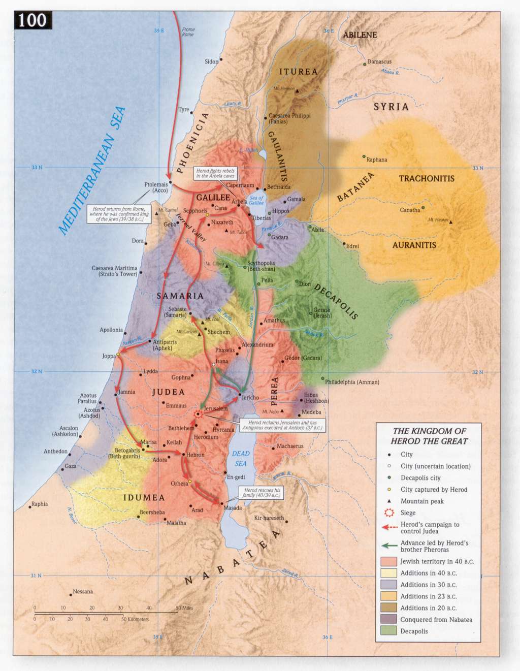
Herod’s Building Program - Holman Bible Atlas. Locates Herod the Great’s major construction projects, including temples, palaces, fortresses, cities, and harbors.
Herod the Great’s Kingdom – Bible-history.com. Identifies the territories, cities, and surrounding regions governed by Herod the Great.
Herod’s Kingdom Divided – Bible-history.com. Shows how Herod’s kingdom was divided among his sons after his death.
Herod’s Temple – Bible-history.com. Illustrates the layout of the Jerusalem temple complex as expanded and renovated by Herod the Great.
The Division of Herod’s Kingdom - Holman Bible Atlas. Shows the territories assigned to Archelaus, Antipas, and Philip following Herod the Great’s death.
Palestine under the Herods - Holman Bible Atlas. Identifies the territories governed by members of the Herodian family during the lives of Jesus and the apostles.
Jesus: Life and Ministry
Jesus’ ministry centered primarily in Galilee and Judea, but the Gospel accounts also take us through Samaria, the Decapolis, Perea, Phoenicia, and Jerusalem.
New Testament World – Bible-history.com. Provides an overview of the Roman world, including the major regions and cities mentioned throughout the New Testament.
Israel in New Testament Times – Bible-history.com. Locates Galilee, Samaria, Judea, and the surrounding regions where most events in the Gospels occurred.
Jerusalem at the time of Jesus – Bible-history.com. Identifies important locations in and around Jerusalem associated with Jesus’ ministry, death, and resurrection.
Jesus’ Early Ministry – Bible-history.com. Traces the places connected with the beginning of Jesus’ public ministry.
Jesus in Galilee – Bible-history.com. Shows the Galilean towns and routes associated with Jesus’ teaching, miracles, and calling of the disciples.
Nazareth-Galilee – Bible-history.com. Locates Nazareth within Galilee and identifies other important towns in the region where Jesus grew up and ministered.
New Testament Jerusalem – Bible-history.com. Shows the major landmarks of Jerusalem during the New Testament period.
Palestine in the Time of Jesus (1) - Holman Bible Atlas. Provides an overview of the political regions, major cities, and neighboring territories of Palestine during Jesus’ lifetime.
Palestine in the Time of Jesus (2) - Holman Bible Atlas. Offers a second view of the regions and locations that form the geographical setting of the Gospels.
Qumran and the Dead Sea Scrolls - Holman Bible Atlas.Locates Qumran and nearby sites associated with the community and caves where the Dead Sea Scrolls were discovered.
Jesus’ Birth and Early Childhood - Holman Bible Atlas. Traces the locations associated with Jesus’ birth, the visit of the Magi, the flight into Egypt, and the return to Nazareth.
The Birth, Childhood, and Baptism of Jesus - Holman Bible Atlas. Follows the events from Jesus’ birth and childhood through his baptism and the beginning of his public ministry.
John the Baptist - Holman Bible Atlas. Shows the region of John’s ministry and the places connected with his preaching, baptizing, and imprisonment.
Galilee in the Time of Jesus - Holman Bible Atlas. Identifies the towns, roads, political boundaries, and natural features of the region where Jesus conducted much of his ministry.
Jesus’ Ministry in Galilee and Journey to Jerusalem - Holman Bible Atlas. Traces Jesus’ work in Galilee and his later journey south toward Jerusalem.
The Ministry of Jesus around the Sea of Galilee - Holman Bible Atlas. Locates the towns and sites around the Sea of Galilee associated with Jesus’ teaching and miracles.
The Ministry of Jesus beyond Galilee - Holman Bible Atlas. Shows Jesus’ travels outside Galilee into surrounding Jewish and Gentile regions.
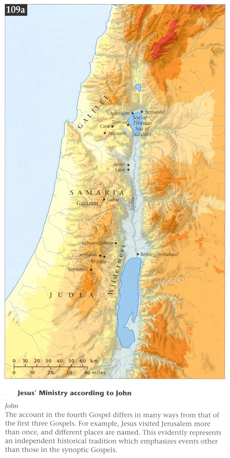
Jesus’ Ministry according to John - Holman Bible Atlas. Traces the principal journeys and locations recorded in John’s Gospel, including Jesus’ repeated visits to Jerusalem.
Jesus’ Journeys from Galilee to Judea - Holman Bible Atlas. Shows the possible routes Jesus followed when traveling between Galilee and Jerusalem.
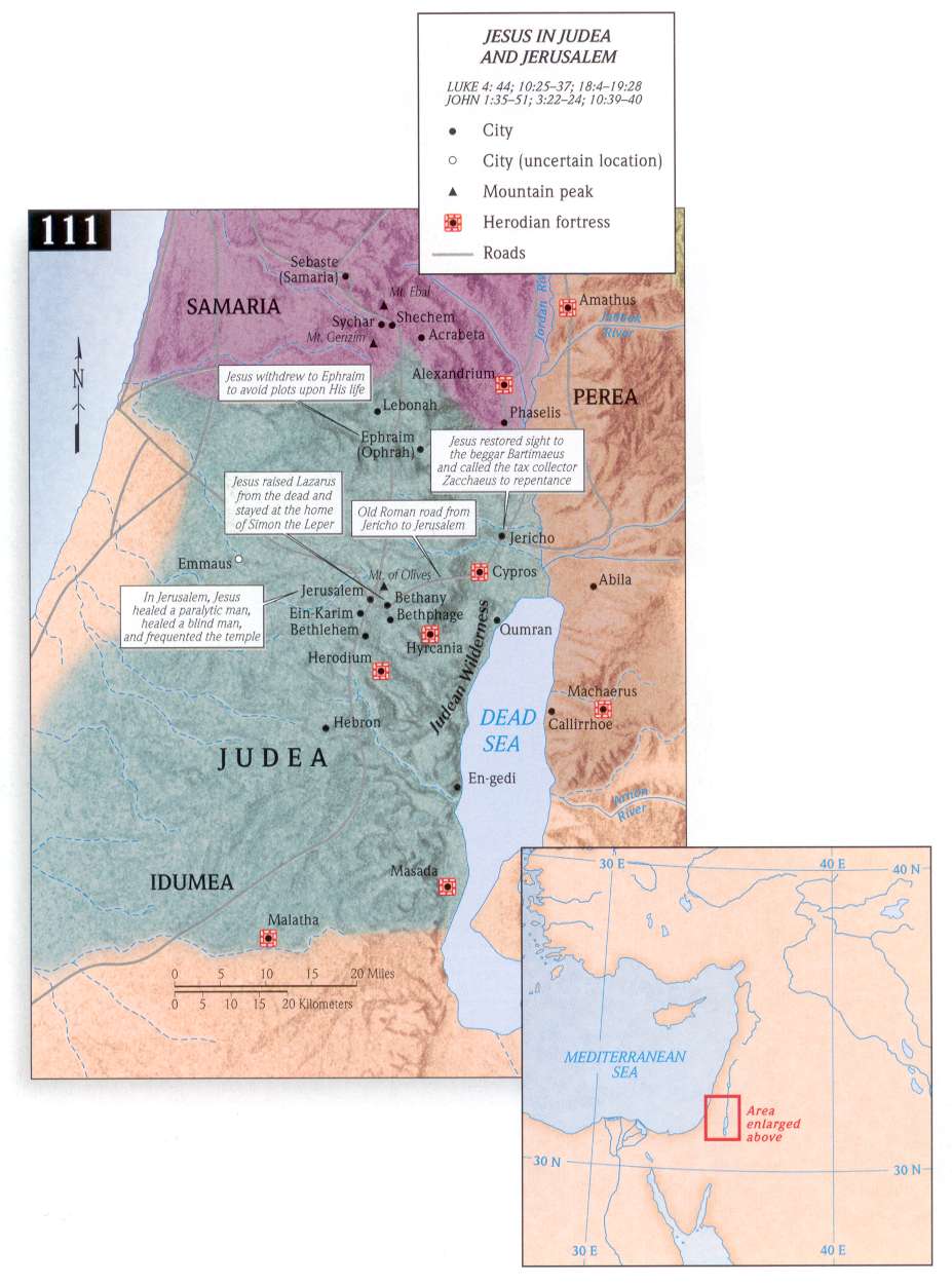
Jesus in Judea and Jerusalem - Holman Bible Atlas. Locates events from Jesus’ ministry in Judea and his final days in Jerusalem.
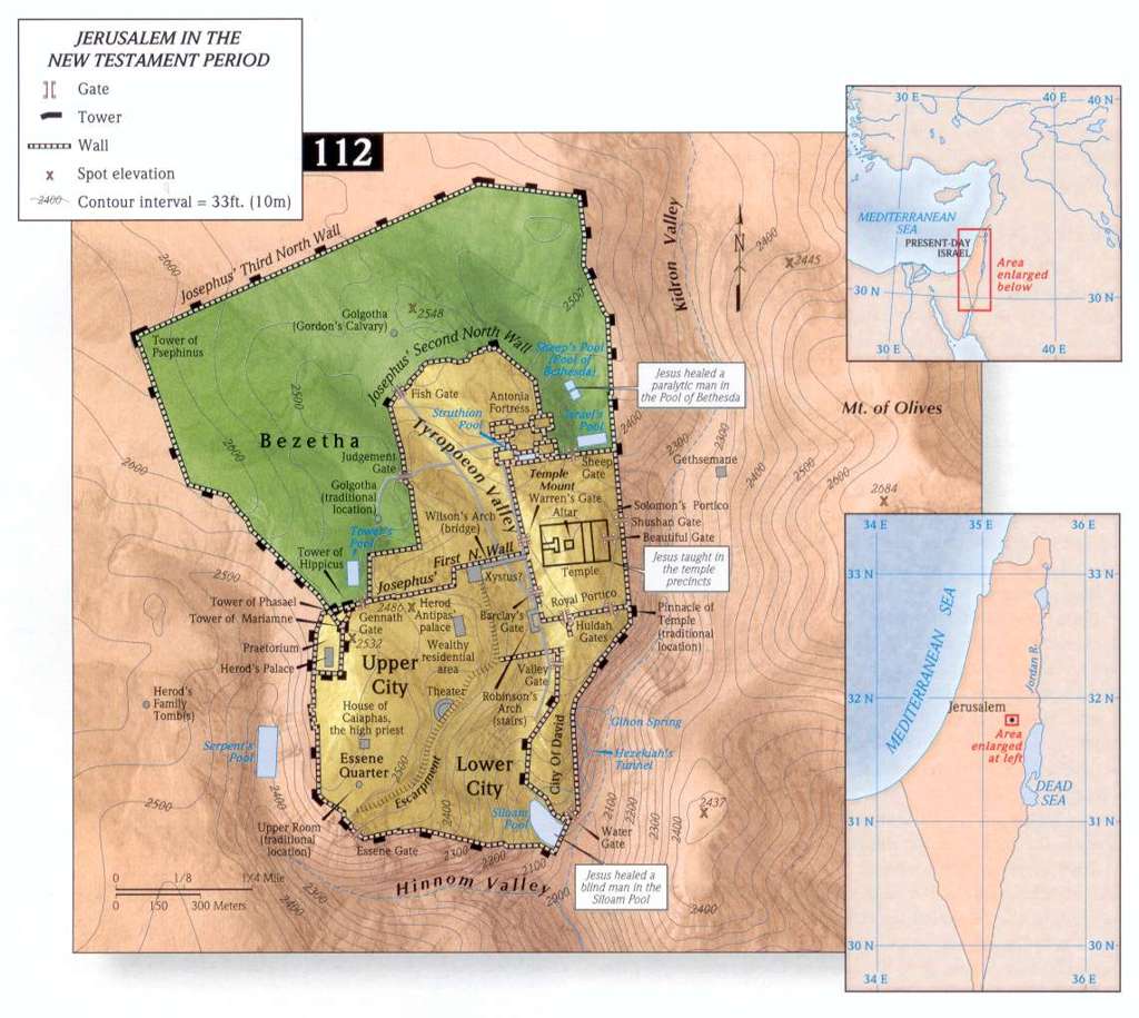
Jerusalem in the New Testament Period - Holman Bible Atlas. Provides a detailed view of Jerusalem’s walls, gates, pools, temple, and other important New Testament locations.
The Passion Week in Jerusalem - Holman Bible Atlas. Locates the principal events associated with Jesus’ final week, crucifixion, burial, and resurrection.
Paul: Life & Ministry
Paul’s journeys explain why his letters address churches scattered across Asia Minor, Macedonia, Achaia, and Rome.
Paul’s Conversion and Early Ministry - Holman Bible Atlas. Follows Paul from his conversion near Damascus through the early years of his Christian ministry.
Paul's First Journey: Traces Paul and Barnabas from Antioch through Cyprus and southern Asia Minor and back again, as recorded in Acts 13–14.
Paul’s 1st Journey – Bible-history.com
The 1st Missionary Journey of Paul - Holman Bible Atlas
Paul's Second Journey: Follows Paul through Asia Minor, Macedonia, and Greece, including his visits to Philippi, Thessalonica, Athens, and Corinth.
Paul’s 2nd Journey – Bible-history.com
The 2nd Missionary Journey of Paul - Holman Bible Atlas
Paul's Third Journey: Traces Paul’s extended ministry in Ephesus and his travels through Macedonia, Greece, and Asia Minor.
Paul’s 3rd Journey – Bible-history.com
The 3rd Missionary Journey of Paul - Holman Bible Atlas
Paul's Journey's Combined
Pauls 1st & 2nd Journeys (Map 13) - English Standard Version Bible. Shows the routes Paul traveled through Cyprus, Asia Minor, Macedonia, and Greece during his first two missionary journeys.
Pauls 3rd Journey & trip to Rome (Map 14) - English Standard Version Bible. Traces Paul’s third missionary journey, his arrest, and his voyage as a prisoner to Rome.
Paul’s Three Journeys on 1 map - Tyndale. Combines Paul’s three major missionary journeys so readers can compare their routes and destinations.
Paul’s Journeys - Holman Bible Atlas. Provides an overview of Paul’s missionary travels across the eastern Roman Empire.
Paul’s Arrest and Imprisonment - Holman Bible Atlas Traces Paul’s movements from his arrest in Jerusalem through his imprisonment and hearings in Caesarea.
Paul’s Voyage to Rome - Holman Bible Atlas. Follows Paul’s dangerous voyage from Caesarea to Rome, including the storm, shipwreck, and stay on Malta.
Maps of Acts and the Early Church
Acts traces the spread of the gospel from Jerusalem into Judea and Samaria and eventually throughout the Roman world.
Israel in New Testament Times – Bible-history.com. Shows the regions and cities of Israel where the apostles first proclaimed the gospel.
Apostles’ Journeys – Bible-history.com. Shows the traditional routes by which the apostles carried the gospel beyond Jerusalem.
World of the New Testament – Bible-history.com. Provides a broad view of the Roman Empire and the cities and regions important to Acts and the New Testament letters.
Apostles Early Ministry (Map 12) - English Standard Version Bible. Traces the spread of the gospel from Jerusalem into Judea, Samaria, and neighboring regions in the opening chapters of Acts.
Pentecost and the Jewish Diaspora - Holman Bible Atlas. Shows the regions represented by the Jewish pilgrims who heard the apostles at Pentecost in Acts 2.
Expansion of the Early Church in Palestine - Holman Bible Atlas. Traces the spread of the gospel from Jerusalem throughout Judea, Samaria, and the surrounding regions.
The Kingdom of Herod Agrippa I - Holman Bible Atlas. Shows the territory governed by Herod Agrippa I, who persecuted the Jerusalem church and executed James.
The Kingdom of Agrippa II - Holman Bible Atlas.Identifies the territory ruled by Agrippa II, before whom Paul defended himself in Acts 25–26.
Spread of Christianity (Map 15) - English Standard Version Bible. Shows the growth of Christianity from Jerusalem across the Roman Empire during the first centuries of the church.
Questions a Map Can Answer
When you encounter an unfamiliar place, first locate it on a regional map. Then ask:
- What political region was it in?
- How far was it from the previous location?
- What terrain or natural boundaries separated the locations?
- Was it predominantly Jewish or Gentile?
- Did a Roman road, port, or trade route make travel easier?
Geography does not determine the meaning of a passage, but it often clarifies the movement, setting, and challenges described in the text.
Maps help us see connections that are easy to miss when we encounter place-names only as words on a page. They show the distances people traveled, the political boundaries they crossed, and the strategic cities from which the gospel spread.
Bookmark this page as a reference whenever you study the Gospels, Acts, or the New Testament letters.
A note about using these maps: Some maps are hosted by Wednesday in the Word, while others link to maps published by outside sources. Copyright and permission requirements vary. Before reproducing a map in a handout, book, presentation, video, or website, consult the terms provided by its original publisher. A link to a map does not grant permission to reproduce it.
Photo by Daniel Gonzalez on Unsplash
Page Views: 6,993